Discover and read the best of Twitter Threads about #californiafires
Most recents (24)

THREAD
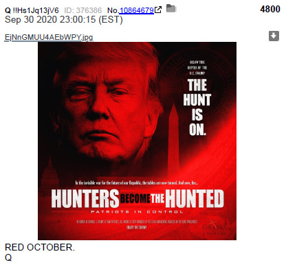
THE WRATH OF GOD - PART 3
RED OCTOBER
Red [fires]
Red [waves]
Red [Chi-na]
Red [dragon]
Red [planet]
Red [Rome]
Red [devil]
RIG FOR RED
THE WRATH OF GOD - PART 3
RED OCTOBER
Red [fires]
Red [waves]
Red [Chi-na]
Red [dragon]
Red [planet]
Red [Rome]
Red [devil]
RIG FOR RED
3.2 - LINKS TO PARTS 1 & 2
PLEASE READ
PART 1 - Intro & The # of Current Events
tinyurl.com/y4u57jfo
PART 2 - Signs of Sodom & of the Revelation
tinyurl.com/yxbwdc5v
And get yourself a copy of a King James #Bible
And #PRAY to #God
🙏
PLEASE READ
PART 1 - Intro & The # of Current Events
tinyurl.com/y4u57jfo
PART 2 - Signs of Sodom & of the Revelation
tinyurl.com/yxbwdc5v
And get yourself a copy of a King James #Bible
And #PRAY to #God
🙏
THREAD
THE WRATH OF GOD - "SECOND" PART 😇
BIGGER THAN ANYONE CAN POSSIBLY IMAGINE
"For the Lord himself shall descend from heaven with a shout, with the voice of the archangel, and with the #trump of #God: and the dead in Christ shall rise first..."
KJV
🙏💪
#GodWins
THE WRATH OF GOD - "SECOND" PART 😇
BIGGER THAN ANYONE CAN POSSIBLY IMAGINE
"For the Lord himself shall descend from heaven with a shout, with the voice of the archangel, and with the #trump of #God: and the dead in Christ shall rise first..."
KJV
🙏💪
#GodWins

2. HE WHO DENIES CHRIST IS THE ANTI-CHRIST
1 JOHN 2:22
Who is a liar but he that denieth that #Jesus is the #Christ?
He is antichrist, that denieth the Father and the Son.
biblehub.com/1_john/2-22.htm
😇🙏💪
1 JOHN 2:22
Who is a liar but he that denieth that #Jesus is the #Christ?
He is antichrist, that denieth the Father and the Son.
biblehub.com/1_john/2-22.htm
😇🙏💪

3. BEFORE WE GET GOING WITH PART 2
If you haven't read Part 1 here is a link😇
tinyurl.com/y4u57jfo
Also read the Book of Revelation please😇 tinyurl.com/yyw3w5bs
Also download the Book of Enoch please😇
sacred-texts.com/bib/boe/
Enoch is an amazing text to have on hand
If you haven't read Part 1 here is a link😇
tinyurl.com/y4u57jfo
Also read the Book of Revelation please😇 tinyurl.com/yyw3w5bs
Also download the Book of Enoch please😇
sacred-texts.com/bib/boe/
Enoch is an amazing text to have on hand


Latest @CopernicusECMWF Atmosphere Monitoring Service @ECMWF aerosol forecast (dataviz @windyforecast windy.com/-Aerosol-aod55…) shows thick smoke covering western US in coming days based on 28/09 #wildfires #AugustComplex #ZoggFire #GlassFire #ShadyFire #RedSalmonComplex
Updated monitoring of #CaliforniaFires with #CopernicusAtmosphere GFAS daily total #wildfire radiative power #opendata confluence.ecmwf.int/display/CKB/CA… showing incredible 6 weeks of activity >> 2003-2019 mean. Hoping that the current increase fails to reach mid-Aug & early-Sept peaks.

Continuing long-range transport of #CaliforniaFires #OregonFires smoke across N America & N Atlantic, reaching Bay of Biscay/Iberian peninsula during 24-25 Sept in latest @CopernicusECMWF @ECMWF aerosol forecast visualized by @windyforecast windy.com/-Aerosol-aod55…
Red skies at sunset photographed by @kelvinmacgregor from Isle of Arran due to long-range transport of #CaliforniaFires #OregonFires smoke across the Atlantic ➡️

High values of aerosol optical depth corresponding to #CaliforniaFires #OregonFires smoke crossing the North Atlantic to the Norwegian Sea & Scandinavia in the #CopernicusAtmosphere Monitoring Service forecast initialized at 00 UTC on 19/09 atmosphere.copernicus.eu/charts/cams/ae…

Looking ahead to 18 UTC on 20/09 shows smoke aerosol from western US #wildfires crossing northern Scotland & could lead to a spectacular sunset. S UK/N France may also see hazy skies with #SaharanDust @liamdutton @Schafernaker @LucyWeather @Lauratobin1 atmosphere.copernicus.eu/charts/cams/ae…


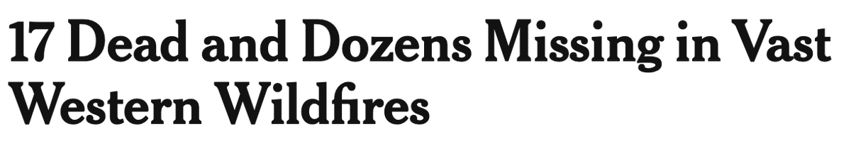
The #NorthComplex Fire is one of the most destructive - and deadliest - in California history. This thread 👇 features ways you can donate and support recovery efforts. A lot of those impacted survived the #CampFire and now have lost homes again. #CaliforniaFires #BearFire
1
1
#NorthComplex #NorthComplexWestZone #BearFire Donation Thread 👇
The @NVCF oversees the Wildfire Relief and Recovery Fund which distributes $$ to nonprofits to support survivors, victims families and recovery.
nvcf.org/wildfire-relie…
2
The @NVCF oversees the Wildfire Relief and Recovery Fund which distributes $$ to nonprofits to support survivors, victims families and recovery.
nvcf.org/wildfire-relie…
2
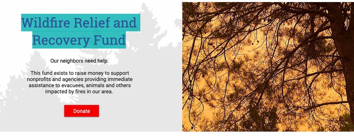
#NorthComplex #NorthComplexWestZone #BearFire Donation Thread 👇
You can snail mail @NVCF gift cards and they will distribute them to folks impacted by fires.
North Valley Community Foundation
The Foundation Building
1811 Concord Ave., Ste. 220
Chico CA, 95928
You can snail mail @NVCF gift cards and they will distribute them to folks impacted by fires.
North Valley Community Foundation
The Foundation Building
1811 Concord Ave., Ste. 220
Chico CA, 95928
🌚GOOD EVENING🌚
Here is your PM report about the #NorthComplex currently burning in #ButteCounty, #PlumasCounty & #YubaCounty. This fire comprises two merged fires: #BearFire & #ClaremontFire. #NorthComplexWestZone #NorthComplexFire
📸PM from Sunset Hill.
1/14
Here is your PM report about the #NorthComplex currently burning in #ButteCounty, #PlumasCounty & #YubaCounty. This fire comprises two merged fires: #BearFire & #ClaremontFire. #NorthComplexWestZone #NorthComplexFire
📸PM from Sunset Hill.
1/14

Here is the latest #NorthComplex #BearFire #NorthComplexWestZone data as of 9/14 PM. The Bear & Claremont Fires merged on 9/7 to form the North Complex. It’s managed by Plumas NF & CAL FIRE.
✅284,437 acres (up from 273,335)
✅40% contained (up from 36%)
✅15 fatalities
2/14
✅284,437 acres (up from 273,335)
✅40% contained (up from 36%)
✅15 fatalities
2/14
#NorthComplexWestZone #BearFire which is managed by CAL FIRE:
✅78,750 acres (up from 77,950)
✅40% contained (up from 35%)
✅15 fatalities
✅1 firefighter injury
✅1,129 destroyed (up from 1,078)
✅72 damaged (up from 64)
3/14
✅78,750 acres (up from 77,950)
✅40% contained (up from 35%)
✅15 fatalities
✅1 firefighter injury
✅1,129 destroyed (up from 1,078)
✅72 damaged (up from 64)
3/14
#NorthComplex #NorthComplexWestZone #BearFire
I will be live tweeting the CAL FIRE update that is streamed on Facebook. Follow this feed 👇.
#ButteCounty #PlumasCounty #YubaCounty #CaliforniaFires
I will be live tweeting the CAL FIRE update that is streamed on Facebook. Follow this feed 👇.
#ButteCounty #PlumasCounty #YubaCounty #CaliforniaFires
#NorthComplex #NorthComplexWestZone #BearFire
Damage assessment teams are mapping damaged, destroyed or non-damaged buildings. Be patient, but it does update daily.
🏘CAL FIRE Damage Assessment Map tinyurl.com/NCStructureRep…
Damage assessment teams are mapping damaged, destroyed or non-damaged buildings. Be patient, but it does update daily.
🏘CAL FIRE Damage Assessment Map tinyurl.com/NCStructureRep…
#NorthComplex #NorthComplexWestZone #BearFire
Damaged residential - 34
Destroyed residential - 727
Damaged commercial - 5
Destroyed commercial - 51
Damaged outbuildings - 33
Destroyed outbuildings - 351
Damaged residential - 34
Destroyed residential - 727
Damaged commercial - 5
Destroyed commercial - 51
Damaged outbuildings - 33
Destroyed outbuildings - 351
🌞GOOD MORNING🌞
Here is your AM report about the #NorthComplex currently burning in #ButteCounty, #PlumasCounty & #YubaCounty. This fire comprises two merged fires: #BearFire & #ClaremontFire. #NorthComplexWestZone #NorthComplexFire
📸AM SW from Meadow Valley camera
1/21
Here is your AM report about the #NorthComplex currently burning in #ButteCounty, #PlumasCounty & #YubaCounty. This fire comprises two merged fires: #BearFire & #ClaremontFire. #NorthComplexWestZone #NorthComplexFire
📸AM SW from Meadow Valley camera
1/21

Here is the latest #NorthComplex #BearFire #NorthComplexWestZone data as of 9/14 PM. The Bear & Claremont Fires merged on 9/7 to form the North Complex. It’s managed by Plumas NF & CAL FIRE.
✅273,335 acres
✅36% contained
✅15 fatalities
✅23,356 structures threatened
2/21
✅273,335 acres
✅36% contained
✅15 fatalities
✅23,356 structures threatened
2/21

Thick smoke from #CaliforniaFires #OregonFires crossing North America & North Atlantic reaching Iceland & Scandinavia over weekend in latest @CopernicusECMWF Atmosphere Monitoring Service @ECMWF aerosol forecast visualized by @windyforecast windy.com/-Aerosol-aod55… #wildfires
Dark area of smoke aerosol from western US #wildfires over cloud in #TerraMODIS visible imagery for 17/09 go.nasa.gov/3iIPkmz corresponding to area of high AOD in #CopernicusAtmosphere forecast for 09UTC atmosphere.copernicus.eu/charts/cams/ae…


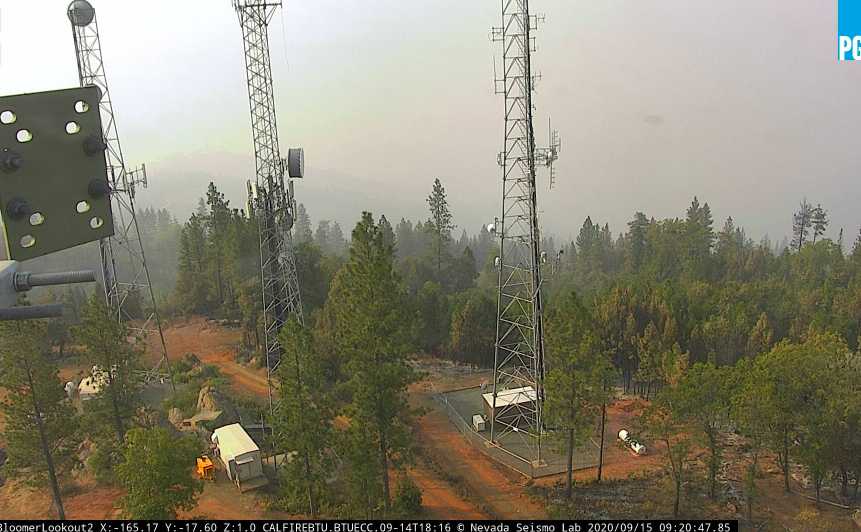
🌞GOOD MORNING🌞
Here is your AM report about the #NorthComplex currently burning in #ButteCounty, #PlumasCounty & #YubaCounty. This fire comprises two merged fires: #BearFire & #ClaremontFire. #NorthComplexWestZone #NorthComplexFire
📸AM from Bloomer Hill
1/19
Here is your AM report about the #NorthComplex currently burning in #ButteCounty, #PlumasCounty & #YubaCounty. This fire comprises two merged fires: #BearFire & #ClaremontFire. #NorthComplexWestZone #NorthComplexFire
📸AM from Bloomer Hill
1/19

Here is the latest #NorthComplex #BearFire #NorthComplexWestZone data as of 9/14 PM. The Bear & Claremont Fires merged on 9/7 to form the North Complex. It’s managed by Plumas NF & CAL FIRE.
✅273,335 acres (up from 269,358)
✅36% contained (down from 39%)
✅15 fatalities
2/19
✅273,335 acres (up from 269,358)
✅36% contained (down from 39%)
✅15 fatalities
2/19
#NorthComplex #BearFire #NorthComplexWestZone
Increased containment on the far SW tip near Oroville.
Today’s 🗺️ tinyurl.com/NorthComplex91…
3/19
Increased containment on the far SW tip near Oroville.
Today’s 🗺️ tinyurl.com/NorthComplex91…
3/19

Thick smoke from continuing #CaliforniaFires #OregonFires crossing N America & eventually N Atlantic towards Iceland🇮🇸 & Norwegian Sea in latest @CopernicusECMWF Atmosphere Monitoring Service @ECMWF forecast visualized by @windyforecast windy.com/-Aerosol-aod55…
Note also sea salt aerosol from #HurricanePaulette, #SaharanDust and smoke from #wildfires in Portugal & Spain #IIFF
Latest monitoring data of daily total intensity & estimated annual total carbon emissions for western US #wildfires with #CopernicusAtmosphere GFAS #opendata confluence.ecmwf.int/display/CKB/CA…. #CaliforniaFires #OregonFires & #WashingtonFires continue >> 2003-2019 mean #wildfires2020 #IIFF


🌞GOOD MORNING🌞
Here is your AM report about the #NorthComplex currently burning in #ButteCounty, #PlumasCounty & #YubaCounty. This fire comprises two merged fires: #BearFire & #ClaremontFire. #NorthComplexWestZone #NorthComplexFire #CaliforniaFires
📸 Bloomer Hill
1/25
Here is your AM report about the #NorthComplex currently burning in #ButteCounty, #PlumasCounty & #YubaCounty. This fire comprises two merged fires: #BearFire & #ClaremontFire. #NorthComplexWestZone #NorthComplexFire #CaliforniaFires
📸 Bloomer Hill
1/25
Here is the latest #NorthComplex #BearFire #NorthComplexWestZone data as of 9/14 PM. The Bear & Claremont Fires merged on 9/7 to form the North Complex. It’s managed by Plumas NF & CAL FIRE.
✅269,358 acres (increased)
✅39% contained
✅15 fatalities
2/25
✅269,358 acres (increased)
✅39% contained
✅15 fatalities
2/25
Here is this morning's map of the #NorthComplex #BearFire #NorthComplexWestZone: tinyurl.com/NorthComplex91…
The black lines around the fire perimeter are containment lines. FS operates N & S zones, CAL FIRE operates West Zone response.
3/25
The black lines around the fire perimeter are containment lines. FS operates N & S zones, CAL FIRE operates West Zone response.
3/25

I am going to live tweet the CAL FIRE #NorthComplex #NorthComplexFIre #BearFire #NorthComplexWestZone Facebook 😑 press conference. Follow this thread. 👇 #CaliforniaFires
Damage inspection teams are currently collecting data on damaged, destroyed and non-damaged properties. You can find the information here: tinyurl.com/NCStructureRep… Updated daily. #NorthComplex #NorthComplexFIre #BearFire #NorthComplexWestZone
#NorthComplex #NorthComplexFIre #BearFire #NorthComplexWestZone
24 damaged residences
376 destroyed residences
4 damaged commercial structures
45 destroyed commercial structures
17 damaged other structures
187 destroyed other structures
24 damaged residences
376 destroyed residences
4 damaged commercial structures
45 destroyed commercial structures
17 damaged other structures
187 destroyed other structures
More hazy skies predicted for W & N Europe with #SaharanDust over next few days in @CopernicusECMWF Atmosphere Monitoring Service @ECMWF aerosol optical depth forecast from 13 Sept atmosphere.copernicus.eu/charts/cams/ae… & more #CaliforniaFires #OregonFires smoke next weekend
Note also high (sea salt) aerosol optical depth associated with #HurricanePaulette

Are you in Oregon right now? Have you spent time in Western Oregon prior to this week? Unless the answer to both those questions is “yes,” you can’t know what we’re going through. #OregonWildfires2020
🔥thread continues...🔥
🔥thread continues...🔥
But it’s not your fault. National news outlets, even the reliable ones like @washingtonpost and @nytimes just aren’t capturing the uniquely dire situation in Oregon. Although @cflav and @henryfountain started to scratch the surface nyti.ms/2Zycepj #OregonWildfires2020
We are not just an extension of California and Washington. We are not just experiencing the next incremental progression of #ClimateChange. This is a weather/ecological event the likes of which the world has not seen in modern history. #OregonWildfires2020

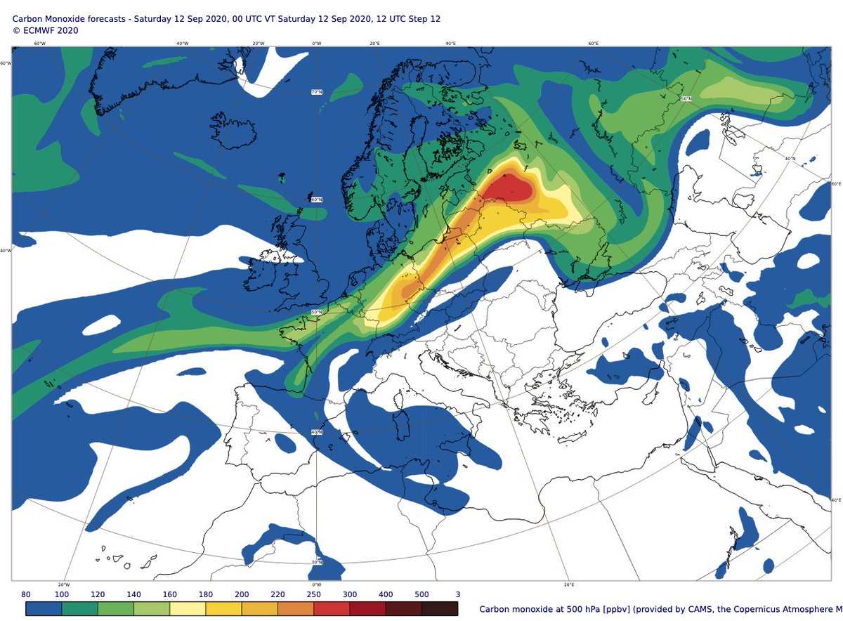
#CaliforniaFires smoke transport over N Europe is clearly apparent in today's #CopernicusAtmosphere Monitoring Service 12 UTC total aerosol optical depth & carbon monoxide at 500hPa (~5km) forecasts. Looking forward to comparing against @IAGOS_RI ✈️ measurements @ThouretV

Explore more with latest charts:
Aerosol optical depth ➡️ atmosphere.copernicus.eu/charts/cams/ae…
Carbon monoxide at 500hPa ➡️ atmosphere.copernicus.eu/charts/cams/ca…
Aerosol optical depth ➡️ atmosphere.copernicus.eu/charts/cams/ae…
Carbon monoxide at 500hPa ➡️ atmosphere.copernicus.eu/charts/cams/ca…
🌞GOOD MORNING🌞
Here is your update on the #OakFire currently burning north of #Willits in #MendocinoCounty. #CaliforniaFires
Things are improving day by day. The inversion layer really helps.
📸Morning from Cleland Mtn looking N towards Oak Fire
1/10
Here is your update on the #OakFire currently burning north of #Willits in #MendocinoCounty. #CaliforniaFires
Things are improving day by day. The inversion layer really helps.
📸Morning from Cleland Mtn looking N towards Oak Fire
1/10

The #OakFire was first reported at 12:16 PM on 9/7 burning off Big John Rd north of Willits. The cause of the fire is under investigation.
✅1100 acres
✅50% containment (up from 40%)
2/10
✅1100 acres
✅50% containment (up from 40%)
2/10
#OakFire as of 9/12 AM
✅25 structures lost
✅20 damaged
✅462 threatened
Morning map: tinyurl.com/OakFire812AM
3/10
✅25 structures lost
✅20 damaged
✅462 threatened
Morning map: tinyurl.com/OakFire812AM
3/10

Updated monitoring of devastating & deadly western US #wildfires with #CopernicusAtmosphere GFAS data based on MODIS active fire obs. Daily total intensity >> 2003-2019 mean & estimated annual total carbon emissions confirm record scale of #CaliforniaFires & #OregonFires #IIFF


Today’s #CopernicusAtmosphere Monitoring Service aerosol optical depth forecast valid for 11 Sept at 00 UTC atmosphere.copernicus.eu/charts/cams/ae… shows #CaliforniaFires smoke over Ireland before crossing UK & North Sea throughout Friday #wildfires #IIFF

@David_P_Moore @colin_seftor @SanGasso @VHPeuch @RichardJEngelen @AntjeInness @Mel_Ades @AtmosChemYork @jimmcquaid @clarenoone @Mace_Head @DrGaryFuller @BBCAmos @dpcarrington @Seana_Davis @liamdutton @Lauratobin1 @DrTELS @centrewildfires @AerosolWatch
Only just noticing the length of the yellow plume (AOD > 0.5) stretching right across the North Atlantic. At first it reminded me of this forecast from June 2019 & link to more information on how we monitor fires & long-range transport of smoke pollution

Hello to everyone suddenly paying attention to the orange skies of the west coast!
Local journalist here, fresh off weeks of interviewing weather, climate, forest, and fire experts to give you . . . a #CaliforniaFires explainer thread:
Local journalist here, fresh off weeks of interviewing weather, climate, forest, and fire experts to give you . . . a #CaliforniaFires explainer thread:

1. Our sky looks crazy because the sunlight is filtering through up to 50,000 feet of smoke and ash to reach the ground.
2. This happens when fires are so
a) big, and
b) intense
that they make their own weather: a column of super-heated air that launches smoke and ash miles up into the atmosphere.
a) big, and
b) intense
that they make their own weather: a column of super-heated air that launches smoke and ash miles up into the atmosphere.

Are you a journalist reporting amid the #CaliforniaFires? #CPJEmergencies' safety advisory on natural disasters and extreme weather includes tips on how to stay safe and prepare while reporting in the field.
Read, bookmark, and share.
More tips below ⤵️
cpj.org/2018/09/physic…
Read, bookmark, and share.
More tips below ⤵️
cpj.org/2018/09/physic…
Threats can materialize quickly during a natural disaster or extreme weather event.
Advice for journalists on how to minimize the risks:
-Quickly identify accommodation that is as secure as possible, along with food and water supplies
-Plan an exit strategy or safe refuge
Advice for journalists on how to minimize the risks:
-Quickly identify accommodation that is as secure as possible, along with food and water supplies
-Plan an exit strategy or safe refuge

If you're covering the #CaliforniaFires, preparing an emergency kit can help you stay safe.
#CPJEmergencies' safety guide includes tips on what to include:
-A fully stocked first aid kit
-A full stock of personal medication
-Iodine tablets or water purification system.
More:
#CPJEmergencies' safety guide includes tips on what to include:
-A fully stocked first aid kit
-A full stock of personal medication
-Iodine tablets or water purification system.
More:


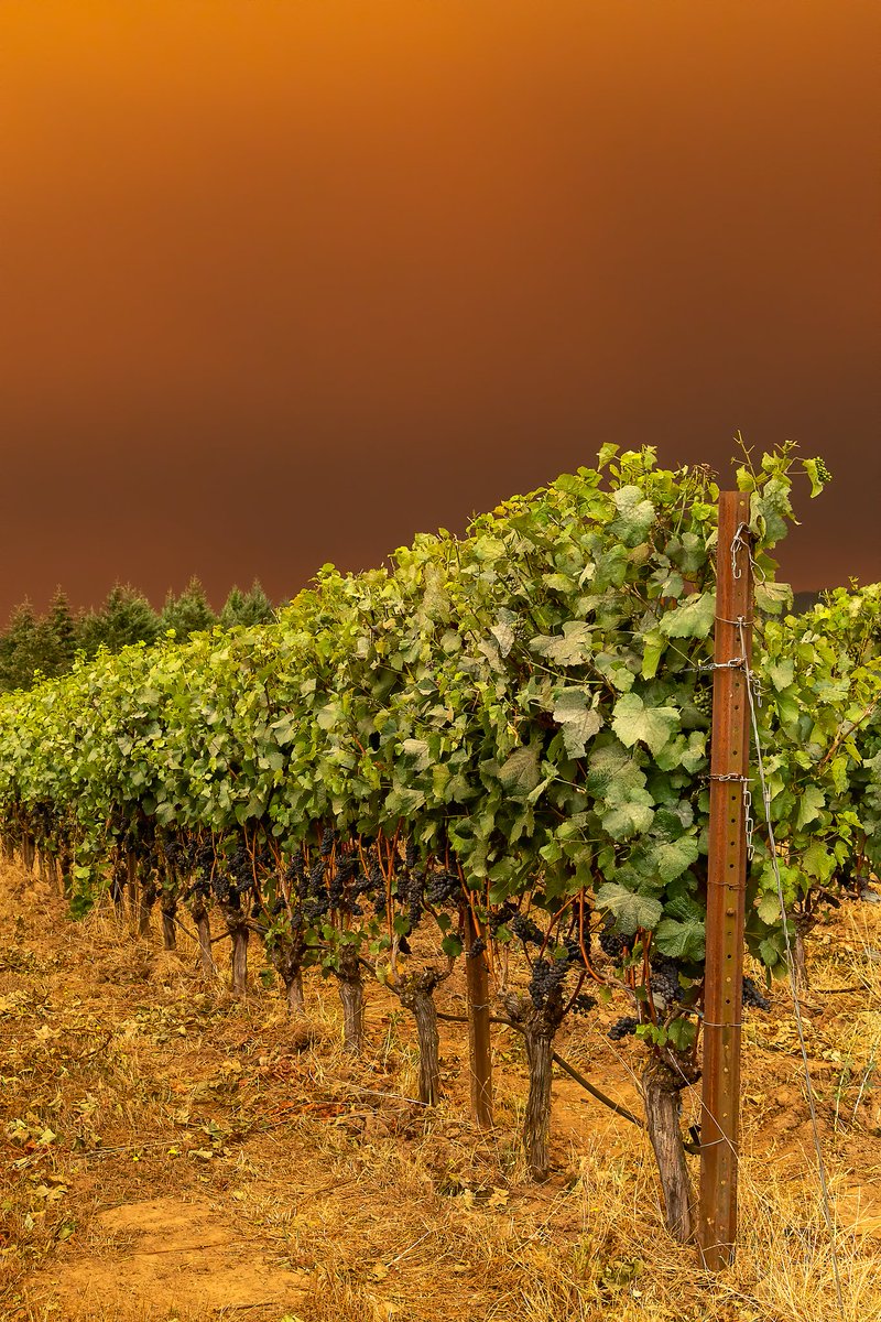
If you woke up this morning and thought you were on Mars instead of the Bay Area, you’re definitely not alone.
Smoke from the #CaliforniaFires has cast an orange glow over #SanFrancisco and the #EastBay.
Smoke from the #CaliforniaFires has cast an orange glow over #SanFrancisco and the #EastBay.


So, what’s going on?
According to @ggweather meteorologist Jan Null, winds are pushing smoke from the north, where multiple wildfires are raging, to the south and into the Bay Area.
sfgate.com/news/editorspi…
According to @ggweather meteorologist Jan Null, winds are pushing smoke from the north, where multiple wildfires are raging, to the south and into the Bay Area.
sfgate.com/news/editorspi…
Here’s some satellite footage of what the smoke looks like over the West Coast:
