Discover and read the best of Twitter Threads about #hurricane
Most recents (24)

Massive 6.4 #earthquake rocks #California leaving people without power | Dec 20
- Its #epicenter was 210 miles north of #SanFrancisco, where a quake hit last week
dailymail.co.uk/news/article-1…
- Its #epicenter was 210 miles north of #SanFrancisco, where a quake hit last week
dailymail.co.uk/news/article-1…

#Hurricane #USNavy #OTD: December 18, 1944, Admiral Halsey catastrophically orders the US Navy’s vaunted TF38 into #TyphoonCobra. TF38 has seven fleet carriers, eight battleships, ~60 light carriers, cruisers, and destroyers. In all, USA loses three... 1/ 


2/ destroyers on Dec. 18 killing 790 sailors. USS Iowa @ussiowa, CL Miami, etc., damaged. Light carriers Langley and Cowpens (above tweet) roll through 70 degrees, sending airplanes overboard or into each other, starting big fires. 146 aircraft lost!!!


3/ In contrast, USA lost 123 aircraft in June 1944 Battle of the Philippine Sea. Destroyers Hull↖️, Monaghan ↗️ and Spence ↙️ sink. Maddox ↘️ and others are pounded but survive. 30 US Navy warships sunk or damaged total! #disasters #WW2 #Pacific #Weather


If you like that Hawaii, California, Arizona, Texas are states, you'll also love it if beautiful #PuertoRico becomes a state. And I'm glad it's under discussion.🇵🇷🇵🇷🇵🇷 #StatehoodForPR independent.co.uk/tv/news/puerto…
2/ #travelbloggers #DiscoverPuertoRico #Love #Beauty - Here's stunning, romantic San Juan, Puerto Rico... I strongly recommend visiting it. You'll love doing so, and you'll help the local economy and wonderful people. Win-win!
3/ #maps #PuertoRico's population exceeds Utah, Iowa, Nevada, Arkansas, Mississippi, Kansas, New Mexico, Nebraska, West Virginia, Idaho, Hawaii, New Hampshire, Maine, Montana, Rhode Island, Delaware, South Dakota, North Dakota, Alaska, Vermont and Wyoming.


#Hurricane #USNavy: December 17/18, 1944, Admiral Halsey catastrophically orders his vaunted TF38 straight into #TyphoonCobra. TF38 has seven fleet carriers, eight battleships, ~60 light carriers, cruisers, and destroyers. In all, the USA loses three... 1/
2/ destroyers on December 18 killing 790 sailors. BB Iowa, CL Miami, etc., damaged. Light carriers like Langley and Cowpens (above tweet) roll through 70 degrees, sending airplanes overboard or into each other, starting bad fires. Total aircraft lost...
3/ ... is 146! In contrast, USA lost 123 aircraft in June 1944 Battle of the Philippine Sea. Destroyers Hull↖️, Monaghan↗️ and Spence↙️ sink. Maddox↘️ and others take heavy poundings but survive. In all, 30 US Navy warships sunk or damaged! #hurricanes
#HurricaneRoslyn #PuertoVallarta #HurricaneSeason #Hurricane - Hurricane Roslyn is a powerful Category 3 hurricane. NATIONAL HURRICANE CENTER has a Hurricane Warning for El Roblito - Puerto Vallarta - Playa Pérula. Mazatlán to Manzanillo under Hurricane Watch. Please be careful!


@ROBERTO71133905 @GoToGuadalajara @TurismoPV @banderasnews @VallartaDaily @PinnacleResorts @VeryPVGays @WeVisitMexico @centerepublican @TravelMexSolo 2/ #HurricaneRoslyn #PuertoVallarta #HurricaneSeason #Hurricane - Hurricane Roslyn from nhc.noaa.gov/refresh/graphi…:

#HurricaneRoslyn #PuertoVallarta #HurricaneSeason #Hurricane - Astonishingly, this track shows Puerto Vallarta just dodging Roslyn though how much difference being outside the blue line will make, I don't know. It looks like Yelapa is just inside the "hit" zone. Photos from 2020.


#Hurricane #Julia landfall near Laguna de Perlas
Computer visualization of where landfall occurred for #Julia

Looks like the eye may have been a direct hit on Laguna de Perlas, per GOES satellite loop.


#HurricaneIan Update.
Additional extraordinary satellite observations.
As Hurricane Ian was making landfall in the Carolinas its atmospheric river exhaust was arriving in the Netherlands & Germany.
Additional extraordinary satellite observations.
As Hurricane Ian was making landfall in the Carolinas its atmospheric river exhaust was arriving in the Netherlands & Germany.
Even the most generous forecasts of the sheer extent of #Hurricane's impacts did not come close. As you can see here in the 12 hours after SC landfall, the Hurricane's remnants brought rain to all of West Virginia and Pennsylvania as well as NYC.
But that was not the end of it, in the evening and overnight yesterday the storm separated from its supporting atmospheric river and continued to revolve over Ohio, NC and Pennsylvania. The center of rotation appears to have been over WV and Eastern NC
This is what I was worried about the interaction between the atmospheric river and #HurricaneIAN.
The Wastern leading edge of the Atmospheric River is now pumping directly into #IAN and it appears to be strengthening over land. The Eyewall is not yet complete.
The Wastern leading edge of the Atmospheric River is now pumping directly into #IAN and it appears to be strengthening over land. The Eyewall is not yet complete.

Earlier threads discussing the interaction phenomena.
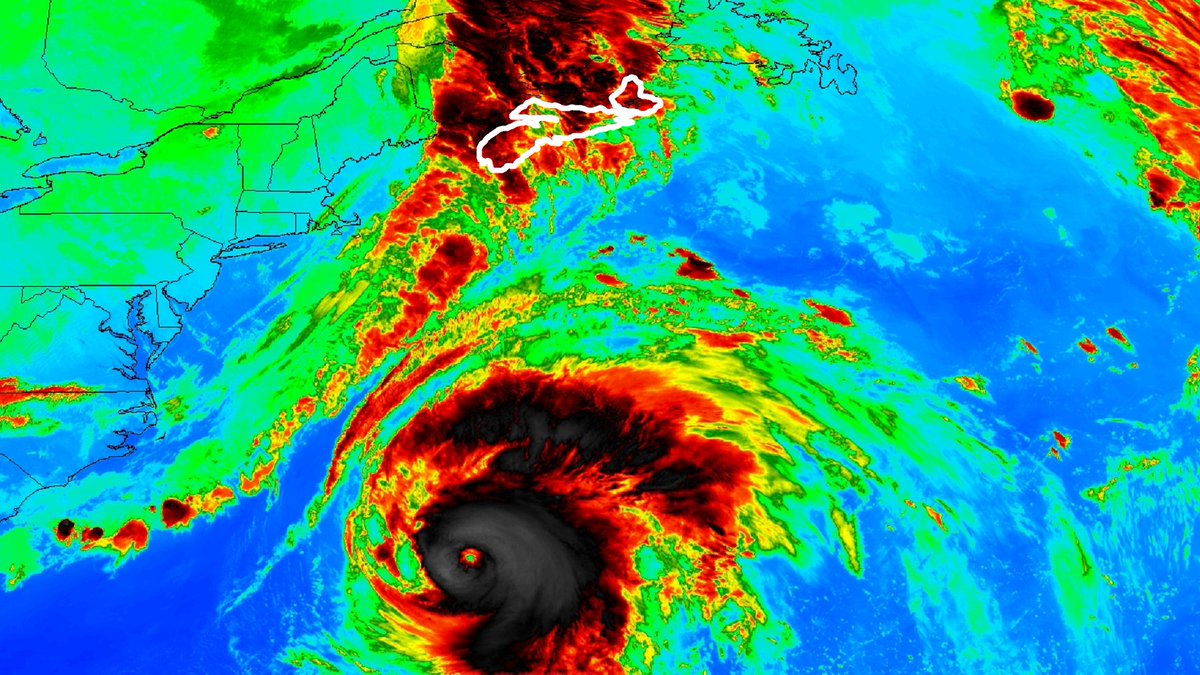
A closeup satelite view of what is likelu the center of #Hurricane IAN coming ashore at Charleston half an hour ago.
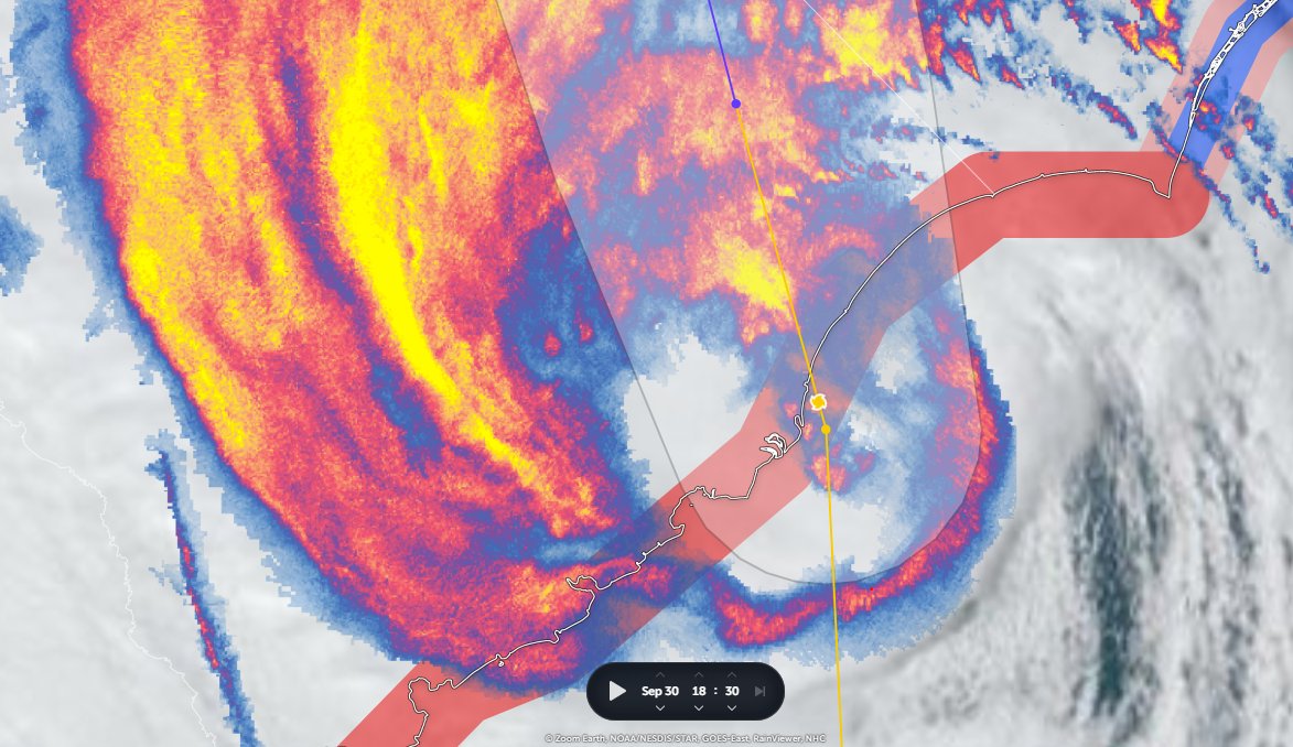
#HurricaneIAN update.
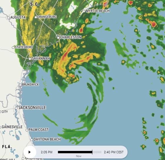
Four radar images over an hour 1-2pm UST.
#HurricaneIAN's motion is not as expected/forecast.
With sunrise approaching energy from the sun increases visibility of the circulation with the development of rain bands in the South Eastern quadrant.
Four radar images over an hour 1-2pm UST.
#HurricaneIAN's motion is not as expected/forecast.
With sunrise approaching energy from the sun increases visibility of the circulation with the development of rain bands in the South Eastern quadrant.


Spaghetti guidance is tightly clustered on Charleston landfall. After moving inland a very sharp turn W/SW is expected with some models even predicting a return back to the Carolina coast.
Tropical rain all the way to the Great Lakes is possible/likely given the size of Ian.
Tropical rain all the way to the Great Lakes is possible/likely given the size of Ian.


Intensity guidance is very clear that the storm is expected to weaken - based on landfall today. This will change rapidly if Ian does not weaken or landfall quickly.
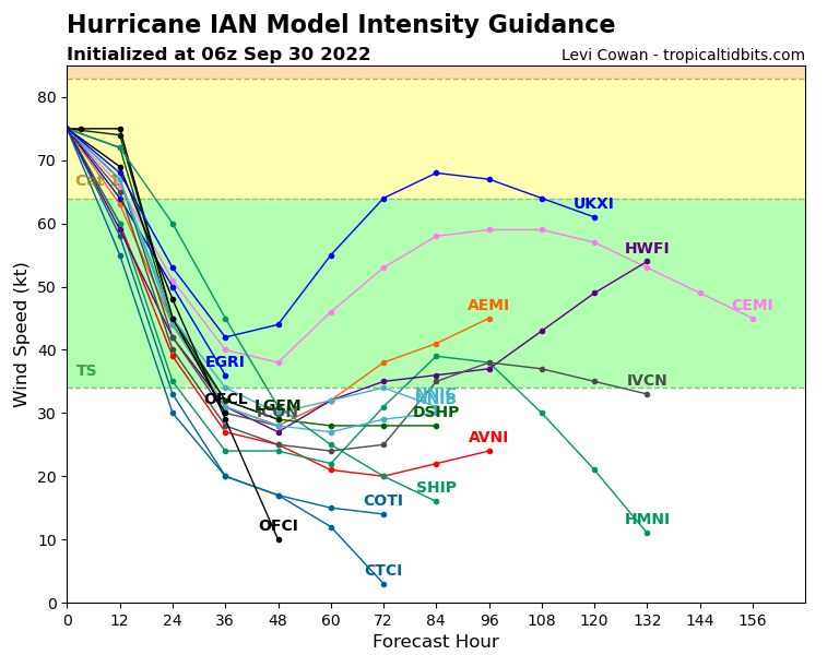
The NHC's forecasting for #HurricaneIAN remains tricky. Inching closer to the North/South Carolina border. And from satellite data, it looks possible that the center of #HurricaneIan is east of the current line.


The specialist HRRR model, which proved more accurate than the main models in predicting the path across Florida is now in agreement with ECMWF, GFS and NAM-CONUS on the location of landfall, but there is a broad range of intensity from 973-984 mb.
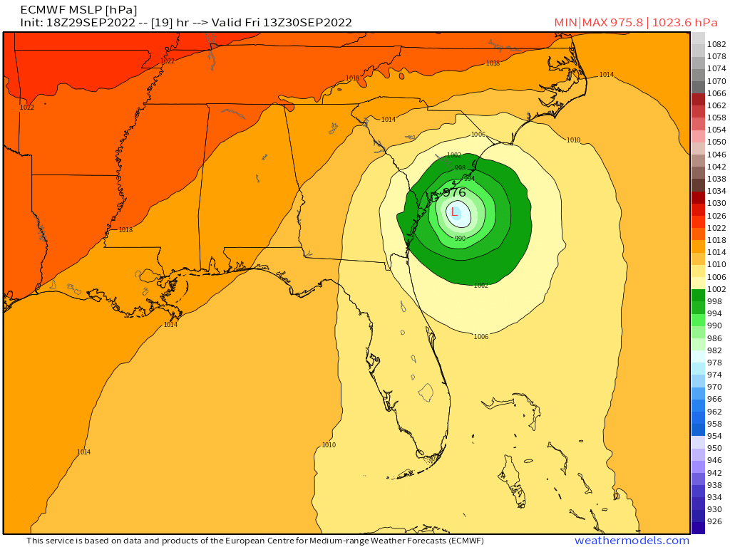


There is also a 6 hour range in arrival time among the four models from 1pm to 7pm. Due to the size of the storm, the impacts of #HurricaneIAN on the Carolinas & beyond are already well and truly underway over night local time.


You’re going to see #HurricaneIan destruction footage and inevitably many of you will think: “They are so stupid! Why didn’t the people in Naple, Ft Myers, etc just LEAVE??”
And while we DO have our fair share of idiots in Florida, most people who stay have a good reason 🧵
And while we DO have our fair share of idiots in Florida, most people who stay have a good reason 🧵
Let’s start w money. We are in a tourist state. So for a place to stay that’s big enough for kids, maybe elderly grandparents, plus pets is AT LEAST a thousand dollars if you stay for 4 days.
That doesn’t count gas, eating out (no kitchen), and packing supplies. 2/
That doesn’t count gas, eating out (no kitchen), and packing supplies. 2/
Avg Florida family makes $57k per year. So there went AT LEAST one week pay for most families if you evacuate.
And if you’re living paycheck to paycheck? Forget leaving unless you have relatives or friends you can stay with. #WhyDidntTheyLeave 3/
And if you’re living paycheck to paycheck? Forget leaving unless you have relatives or friends you can stay with. #WhyDidntTheyLeave 3/

🌪
(1) Today's story was the destruction caused by Hurricane Ian in Florida. It is one of the strongest hurricanes ever to strike Florida, and in the coming days, we will learn more about the damage and victims.
🧵 Beginning of a thread
#HurricaneIan
(1) Today's story was the destruction caused by Hurricane Ian in Florida. It is one of the strongest hurricanes ever to strike Florida, and in the coming days, we will learn more about the damage and victims.
🧵 Beginning of a thread
#HurricaneIan
🌪
(2) Expect lots of shocking photos and heartbreaking videos on social media that will remind us of the power of nature, specifically when boosted by the additional energy we have trapped in the system.
🧵 #IanHurricane #Hurricane_Ian
(2) Expect lots of shocking photos and heartbreaking videos on social media that will remind us of the power of nature, specifically when boosted by the additional energy we have trapped in the system.
🧵 #IanHurricane #Hurricane_Ian
🌪
(3) Man-made climate change has raised sea levels and warmed the oceans, which fueled Ian to a hurricane that, at a certain point, was just two mph shy of a Category 5.
🧵 #climatecrisis #Ian #Hurricane
(3) Man-made climate change has raised sea levels and warmed the oceans, which fueled Ian to a hurricane that, at a certain point, was just two mph shy of a Category 5.
🧵 #climatecrisis #Ian #Hurricane
🌪
(1) Storm surge of #HuricaneaIan is seen pushing into #Naples, FL
Thread 🧵
#Ian via @growingwisdom
(1) Storm surge of #HuricaneaIan is seen pushing into #Naples, FL
Thread 🧵
#Ian via @growingwisdom
🌪
(3) Overnight, Hurricane Ian gained strength. It is now a monster storm in Category 4, and at 155 mph, it gets very close to a Category 5 hurricane.
➡️ theplanet.substack.com/p/hurricane-ia…
#Ian #HurricaneIan #climate #weather #Florida #Tampa #news
(3) Overnight, Hurricane Ian gained strength. It is now a monster storm in Category 4, and at 155 mph, it gets very close to a Category 5 hurricane.
➡️ theplanet.substack.com/p/hurricane-ia…
#Ian #HurricaneIan #climate #weather #Florida #Tampa #news

Fort Myers Beach, Florida* this is off Estero Blvd
A lot of people asking to share this video. Here is a link to the rightful owner - instagram.com/loniarchitects/

🔴 Hurricane Ian – live coverage: Eyewall comes onshore in Florida as warnings of ‘unsurvivable’ surge in places
independent.co.uk/climate-change…
independent.co.uk/climate-change…
The eyewall of Hurricane Ian barrelled onshore in Florida at 11am on Wednesday as forecasters warned that some places on the west coast could see “unsurviveable” storm surge.
independent.co.uk/climate-change…
independent.co.uk/climate-change…
Destructive waves are expected along the southwest coast from Englewood to Bonita Beach including Charlotte Harbor, near the town of Punta Gorda, north of Fort Myers.
independent.co.uk/climate-change…
independent.co.uk/climate-change…
Pinellas County has A,B,C, "recommended" and will issue mandatory evacuations tomorrow. #Hurricane #Ian #FL
#Pinellas Evacuation discussion #HurricaneIan

#Ian spinning (with a visible eye) south of Cuba this morning. (via GOES satellite).
If you left your rocket ship parked outside, you might be thinking about putting it back in the garage, I think.


Tropical storm force wind arrival times for #Ian

Preparation tasks for residents within the forecast cone for soon to be #hurricane #ian

In all seriousness now... Much of #NovaScotia is now under a #Hurricane WARNING, including capital city, Halifax. #FIONA will race this way, with center reaching the coast Saturday morning. My plan is commonsense: 1/5
Heading E at crack of dawn to Cape Breton Island where I'll set up HQ in Sydney (on E end). Since FIONA will be embedded in strong steering flow, & since it'll be a large target (no tight, tropical core like in Dominican Republic), I'm expecting straightforward chase. 2/5
Being diehard nerd, I'm most excited about the air-pressure data. Here are lowest pressures I've recorded in decades of chasing. Where's #FIONA gonna score on this list? Curious. P.S. Global models suck with intensity & I think they're overcooking FIONA's at landfall up here. 3/5

Before/after flooding near Yabucoa, #PuertoRico due to #Fiona (Sentinel-1 satellite).
Before/after flooding near Gurabo, #PuertoRico via Sentinel-1 satellite and @sentinel_hub (9/19/2022)
Before/after flooding in and around Naguabo #PuertoRico (via Sentinel-1 satellite). It looks like PR-927 heavily impacted by flooding, the satellite seems to indicate flooded streets in Naguabo itself. #Fiona

WEATHER: While #HurricaneFiona Is A Relatively Weak #Hurricane, #PuertoRico Is In Serious Danger From Massive #Flooding Amplified By Training/Orographic Lift!
This Is An Incredibly Life-Threatening Situation Especially On The Southern Half Of #PuertoRico
This Is An Incredibly Life-Threatening Situation Especially On The Southern Half Of #PuertoRico
UPDATE: This Was The Eye Of #HurricaneFiona As It Crossed #CaboRojo #PuertoRico
Photo By: 📸 Luis A. Ramírez
Photo By: 📸 Luis A. Ramírez

UPDATE: The Entire Island Of #PuertoRico Is Without Power As #HurricaneFiona Dumps Massive Amounts Of Flooding Rains Destroying The Islands Infrastructure!

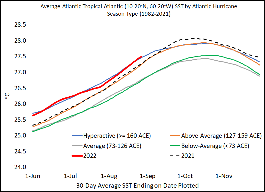
For the first time since 1941, the Atlantic has had no named storm (e.g., tropical storm or #hurricane) activity from July 3rd-August 30th.
Since 1950, two Augusts have had no Atlantic named storm formations: 1961 and 1997. It remains to be seen if 2022 will join this list. 1961 ended up a hyperactive #hurricane season with an extremely busy September-November, while 1997 was a below-average season.
This remarkable quiet period is even more impressive given we have a robust #LaNina in the tropical Pacific and anomalously warm tropical Atlantic. Current 30-day-averaged tropical Atlantic sea surface temperatures are 6th warmest since 1982 and typical of a hyperactive season.