Discover and read the best of Twitter Threads about #MIwx
Most recents (3)

True Color RGB images from @NOAASatellites #GOES16/#GOESeast showed large plumes of blowing #dust across parts of New Mexico, Texas ad Oklahoma on 22 Feb: geosphere.ssec.wisc.edu/#playing:true;…; Note the brighter white plume originating from White Sands NM. #NMwx #TXwx #OKwx
...and here's a comparison of the blowing dust plumes as viewed using True Color RGB images from 3 satellites - @NOAASatellites #GOES18/#GOESwest, #GOES17 and #GOES16/#GOESeast: cimss.ssec.wisc.edu/satellite-blog… #NMwx #TXwx #OKwx 
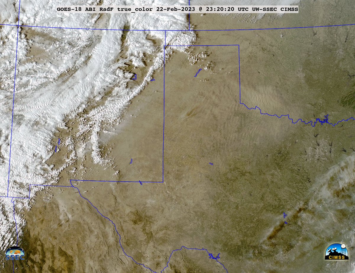


This morning, evidence of the airborne dust (shades of tan) from NM/TX/OK could be seen in @NOAASatellites #GOES16/#GOESeast True Color RGB images over parts of #ILwx/#INwx/#OHwx/#MIwx/#KYwx: geosphere.ssec.wisc.edu/#playing:true;…;

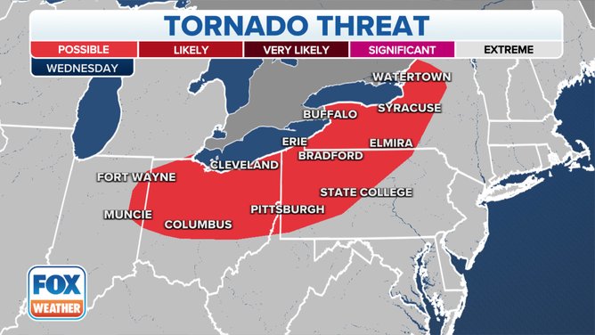
A Severe Thunderstorm Watch has been issued across southeastern #Michigan until 1 p.m. ET. bit.ly/3BSVNX5 #MIwx

The Severe Thunderstorm Watch includes the cities of Flint and Detroit.
As the day continues, storms will fire up and grow in intensity as they sweep across areas from eastern #Ohio and western #Pennsylvania to western and central #NewYork state. bit.ly/3BSVNX5 #MIwx
As the day continues, storms will fire up and grow in intensity as they sweep across areas from eastern #Ohio and western #Pennsylvania to western and central #NewYork state. bit.ly/3BSVNX5 #MIwx

Damaging winds and large hail are the main threats that will be associated with any severe thunderstorms that develop on this afternoon and evening.
However, flash flooding and tornadoes are also possible within any of the stronger thunderstorms. bit.ly/3BSVNX5
However, flash flooding and tornadoes are also possible within any of the stronger thunderstorms. bit.ly/3BSVNX5


A lot to talk about in the weather world!
It's a hot Tuesday (closing in on 90°), but Cristobal is knocking on the doorstep. Rain, wind, and potential stronger storms... it's an active forecast overnight into late Wednesday #miwx
It's a hot Tuesday (closing in on 90°), but Cristobal is knocking on the doorstep. Rain, wind, and potential stronger storms... it's an active forecast overnight into late Wednesday #miwx
WIND: A likely impact all across N. Michigan, but especially those near Lake Michigan. Gusts nearing 45MPH are expected here, possibly even higher in isolated spots.
Peak gusts only last overnight Tue. - early Wed., but still breezy (20-30+MPH) through Thursday.
Peak gusts only last overnight Tue. - early Wed., but still breezy (20-30+MPH) through Thursday.


RAIN: Widespread, locally heavy, rain is greatest overnight with first round - PWATS at extraordinary levels for N. Michigan. First round only lasts ~6 hours, keeping rain amounts in check.
We'll still keep an eye on flash flooding (it's been a wet spring), but looks limited.
We'll still keep an eye on flash flooding (it's been a wet spring), but looks limited.


