Discover and read the best of Twitter Threads about #ColoradoFires
Most recents (11)

Are you in Oregon right now? Have you spent time in Western Oregon prior to this week? Unless the answer to both those questions is “yes,” you can’t know what we’re going through. #OregonWildfires2020
🔥thread continues...🔥
🔥thread continues...🔥
But it’s not your fault. National news outlets, even the reliable ones like @washingtonpost and @nytimes just aren’t capturing the uniquely dire situation in Oregon. Although @cflav and @henryfountain started to scratch the surface nyti.ms/2Zycepj #OregonWildfires2020
We are not just an extension of California and Washington. We are not just experiencing the next incremental progression of #ClimateChange. This is a weather/ecological event the likes of which the world has not seen in modern history. #OregonWildfires2020

Escalation of devastating #wildfires, smoke & surface #airpollution across entire western US with very high levels of surface PM2.5 for the coming days. @CopernicusECMWF Atmosphere Monitoring Service @ECMWF forecast initialized 9 Sept at 00 UTC visualized by @windyforecast
Link to forecast ➡️ windy.com/-PM2-5-pm2p5?c… #CAwx #CaliforniaFires #ORwx #OregonFires #WAwx #WashingtonFires #COwx #ColoradoFires #UTwx #UtahFires
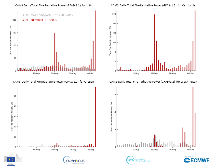
1 Aug - 8 Sept 2020 daily total #wildfire radiative power (cf 2003-2019 mean) for US, #CaliforniaFires, #OregonFires & #WashingtonFires from #CopernicusAtmosphere Monitoring Service GFAS data confluence.ecmwf.int/display/CKB/CA… based on NASA MODIS 🛰️ active fire observations #wildfireseason
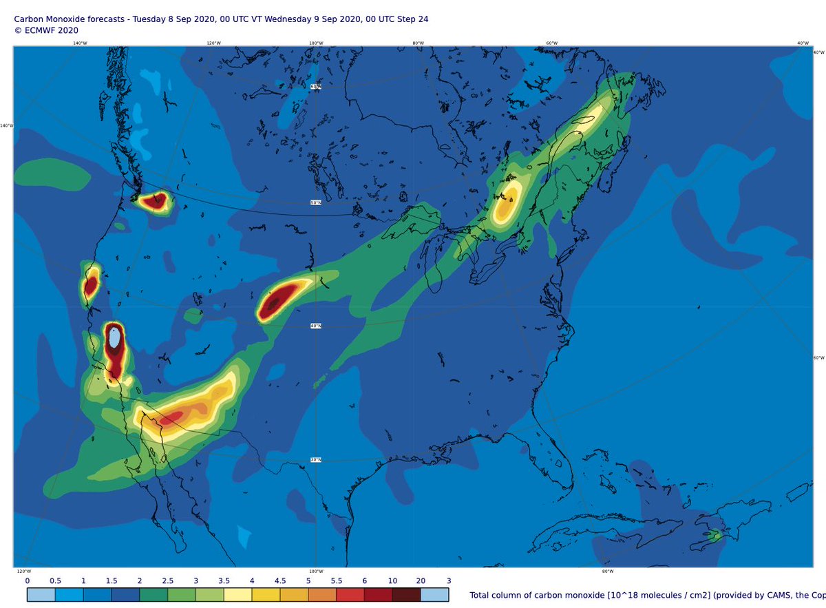
Clear increase in daily total intensity of #CaliforniaFires & #ColoradoFires on 7 Sept >> 2003-2019 mean in #CopernicusAtmosphere GFAS data. Latest 24-hour aerosol & carbon monoxide forecasts show long-range transport of smoke extending across the US from SW to NE.


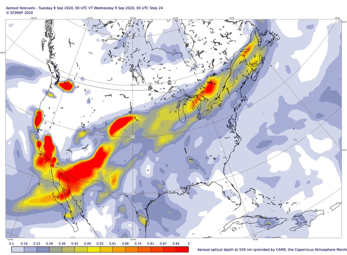
Aerosol forecast charts ➡️ atmosphere.copernicus.eu/charts/cams/ae…
Carbon monoxide forecast charts ➡️ atmosphere.copernicus.eu/charts/cams/ca…
Carbon monoxide forecast charts ➡️ atmosphere.copernicus.eu/charts/cams/ca…
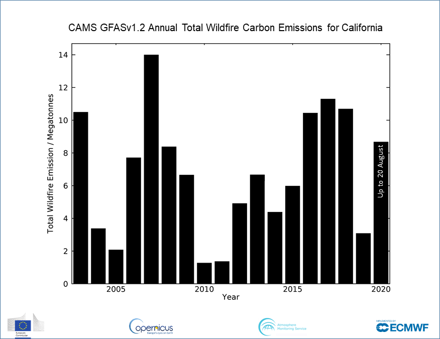
Incredible scale of ongoing #CaliforniaFires with total estimated #wildfire emissions for California to 7 Sept 2020 already state’s highest annual total in 18-year #CopernicusAtmosphere GFAS dataset (Colorado achieved this in August) confluence.ecmwf.int/display/CKB/CA… #CAfire #COfire


A lot of aerosol over the Atlantic with smoke from #CaliforniaWildfires #ColoradoFires & #SaharanDust in the north, smoke from S tropical Africa/South America fires in the south. Latest @CopernicusECMWF Atmosphere Monitoring Service @ECMWF forecast visualized by @windyforecast
Explore more at windy.com/-Aerosol-aod550
Quick initial evaluation of #CopernicusAtmosphere Monitoring Service AOD forecasts in relation to long-range transport of #CaliforniaFires & #ColoradoFires smoke vs. Aeronet measurements at Fresno & @NASAAmes CA, Sterling CO, Missoula MT, N Great Plains ND & Sioux Falls SD

More info on Aeronet measurements at aeronet.gsfc.nasa.gov. #Copernicus Atmosphere Monitoring service forecasts are initialized from analyses which assimilate satellite observations - independent measurements such as Aeronet are essential to evaluation and validation
Busy days over the North Atlantic with smoke from #CaliforniaFires #ColoradoFires & #SaharanDust moving around Azores high in @CopernicusECMWF Atmosphere Monitoring Service @ECMWF aerosol optical depth forecast visualized by @windyforecast windy.com/-Aerosol-aod55… @CopernicusEU

#Water gets rid of #wildfires, and wildfires get rid of water
#ColoradoFires #colorado #river #wildfire #watersecurity #drought coloradosun.com/2020/08/19/gri…
#ColoradoFires #colorado #river #wildfire #watersecurity #drought coloradosun.com/2020/08/19/gri…
“In many ways, the #GrizzlyCreekFire is a public works fire, threatening the viral #infrastructure for millions of westerners”
“ground crews are not fighting flames in the precipitous Glenwood Canyon. They can’t even reach them.”
#firefighters #firefighting #cofire
#firefighters #firefighting #cofire
Smoke from #CaliforniaFires already covering huge area of western US/Canada & predicted to continue eastwards across the Great Lakes to the North Atlantic in @CopernicusECMWF Atmosphere Monitoring Service @ECMWF forecast visualized by @windyforecast windy.com/-Aerosol-aod55…
Daily total fire radiative power of #CaliforniaFires & #ColoradoFires continues >> 2003-2019 mean in #CopernicusAtmosphere GFAS data with 2020 already the highest annual total estimated #wildfire carbon emissions for Colorado.


Thick smoke plumes from escalating scale & intensity of #wildfires in California, Colorado & western US predicted to spread across N America in latest @CopernicusECMWF Atmosphere Monitoring Service @ECMWF aerosol forecast visualized by @windyforecast windy.com/-Aerosol-aod55…
#AirPollution related to #CaliforniaWildfires & #ColoradoWildfires affecting huge area in #CopernicusAtmosphere Monitoring Service 24-hour forecasts (init 00 UTC, 20/08/2020) of ⬅️total column carbon monoxide, ↗️surface CO concentration & ↘️surface PM2.5 concentration #airquality


Latest charts at atmosphere.copernicus.eu/charts/cams/
Several #wildfires across the western US & large area of high predicted surface PM2.5 #AirPollution in the latest @CopernicusECMWF Atmosphere Monitoring Service @ECMWF forecast visualized by @windyforecast windy.com/-PM2-5-pm2p5?c… #CaliforniaFires #ColoradoFires @CopernicusEU
GFAS daily total #wildfire intensity showing scale of fires in Colorado & California >> 2003-2019 mean in recent days #LoyaltonFire #LakeFire #CameronPeakFire #PineGulchFire #GrizzlyCreekFire


Large smoke plumes from devastating #PineGulchFire CO, #PoodleFire NV, #LakeFire CA & other #wildfires in latest 5-day @CopernicusECMWF Atmosphere Monitoring Service @ECMWF aerosol optical depth forecast visualized by @windyforecast windy.com/-Aerosol-aod55… @CopernicusEU
@ESA_EO @eumetsat @Atmospheric_SAF @defis_eu @NASAEarth @AerosolWatch @NCAR_ACOM @FireWeatherLab @wildfiretoday @IAWF @CAL_FIRE @RMACCinfo @NevadaFireInfo @jmccarty_geo @RussellDengel @SeverePlains @BrandonCNN @Pierre_Markuse @OroraTech @EUintheUS
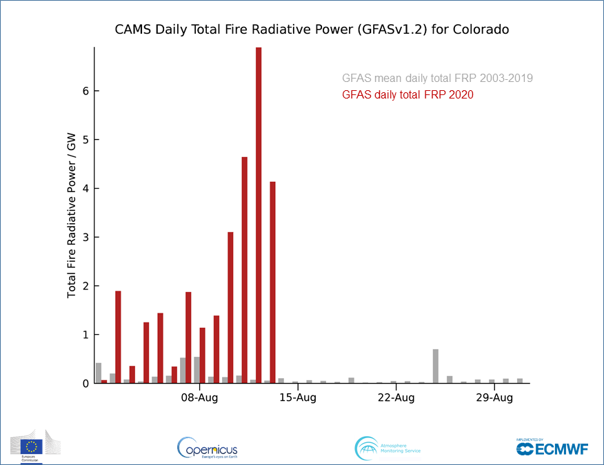
Increasing scale & intensity of #ColoradoFires since 1 August >> 2003-2019 average in #CopernicusAtmosphere Monitoring Service GFAS #opendata confluence.ecmwf.int/display/CKB/CA…. Estimated total smoke emissions to 13th already tower above previous August totals for the state #COFire #cowx